Swyddi Tanysgrifio i Swyddi Blog Treftadaeth Cymru News      Pob Sylw Tanysgrifio i Heritage of Wales Sylwadau Blog Newyddion     English
Showing posts with label Archaeoleg Cymru. Show all posts

Tuesday, 14 June 2016

Dehongli ac ymweld ag archaeoleg Ynys Sgomer


Louise Barker (yn pwyntio) yn gweithio gyda Swyddog Ymwelwyr Sgomer a gwirfoddolwyr o Ymddiriedolaeth Bywyd Gwyllt De a Gorllewin Cymru ar ymweliad diweddar ag Ynys Sgomer.
Mae archaeoleg Ynys Sgomer, Sir Benfro, wedi’i chadw’n arbennig o dda. Ar draws yr ynys gellir gweld olion ffiniau wedi’u creu â chlogfeini, waliau cerrig taclus, a sylfeini tai crwn. Dengys y rhain i lawer o’r ynys gael ei ffermio yn ystod yr Oes Haearn a’r cyfnod Brythonaidd-Rufeinig rhwng 2,000 a 2,500 o flynyddoedd yn ôl. Mae maen hir amlwg, Maen Harold, a megalithau eraill yn awgrymu bod pobl yn byw yma yn llawer cynharach na hyn, yn yr Oes Neolithig a’r Oes Efydd Gynnar.
Tŷ crwn o’r Oes Haearn neu’r cyfnod Brythonaidd-Rufeinig yn y Wick ar Ynys Sgomer. Golwg yn dangos y drws.
Yn sgil arolygon archaeolegol a chloddiadau newydd gan y Comisiwn Brenhinol, ar y cyd â chydweithwyr o Brifysgol Sheffield, Prifysgol Caerdydd a Cadw, mae Ymddiriedolaeth Bywyd Gwyllt De a Gorllewin Cymru, sy’n rheoli Sgomer, yn gobeithio gwella’r arwyddion ar yr ynys a’r wybodaeth am ei harchaeoleg yn ystod 2016.

Tua diwedd Mai, teithiodd Louise Barker a Toby Driver, archaeolegwyr y Comisiwn Brenhinol, i Sgomer i gyfarfod â Leighton Newman, Swyddog Ymwelwyr Sgomer, a Hannah, gwirfoddolwraig ers blynyddoedd, i siarad am archaeoleg yr henebion cynhanesyddol mwyaf gweladwy. Gobaith Leighton a Hannah yw adnewyddu rhannau o Lwybr Hanes Sgomer, a sefydlwyd gyntaf ar ôl gwaith a wnaed gan yr Athro John Evans yn y 1980au.

Mae un o’r tai crwn cynhanesyddol mwyaf hygyrch a thrawiadol yn Sir Benfro i’w weld yn y Wick, yn agos at un o’r prif wylfannau Palod. Gosodwyd arwydd newydd yno i ddangos safle’r tŷ. Gall ymwelwyr gerdded i mewn i sylfeini’r tŷ crwn, drwy ei borth amlwg, a dychmygu’r olygfa ddomestig o fewn ei furiau ddwy fil o flynyddoedd yn ôl.
Un o’r arwyddion newydd sy’n gwahodd ymwelwyr i archwilio’r tŷ crwn cynhanesyddol yn y Wick.
Mae’n bosibl bod gan y tŷ wal o blethwaith a choed a tho conig yn wreiddiol. Er bod coed ar gyfer adeiladu yn brin ar Ynys Sgomer yn yr Oes Haearn, gellid fod wedi cludo pyst, polion a defnyddiau adeiladu eraill i’r ynys ar gwch. Mae’r Comisiwn Brenhinol yn parhau i weithio gyda’r Ymddiriedolaeth Bywyd Gwyllt i godi ymwybyddiaeth o drysorau archaeolegol Sgomer. Os hoffech ymweld ag Ynys Sgomer, ewch i’r wefan: http://www.welshwildlife.org/skomer-skokholm/skomer/

Gan Toby Driver, RCAHMW


Tanysgrifiwch i Newyddion Treftadaeth Cymru a chofrestrwch ar gyfer yr RSS porthiant llawn: cliciwch y botwm RSS hwn Tanysgrifiwch i Newyddion Treftadaeth Cymru a thanysgrifiwch!


Rhannu ar:
Twitter   •   Facebook   • Google+   • Linkedin


Rydym hefyd ar gael ar:
Facebook Twitter Google-plus YouTube Facebook Flickr

Twitter Hashtag: #RCAHMWales

Share this post:

Wednesday, 6 April 2016

Latest News from the Skomer Island Project - The 2016 Fieldwork Season


Last week, the Skomer Island Project team returned to Skomer to undertake the latest phase of archaeological research on the Island. This year archaeologists Louise Barker and Toby Driver (RCAHMW), Bob Johnston (University of Sheffield) and Oliver Davis (Cardiff University) were delighted to be joined by geographer and environmental scientist Sarah Davies of Aberystwyth University.

Skomer Island, Pembrokeshire is famed for its wildlife and for the survival of its ancient field systems which are amongst the best preserved anywhere in Britain. (© Crown Copyright: RCAHMW, AP_2010_3294)
The aims of this year’s work were twofold; to excavate one of the Island’s main archaeological features, a prehistoric field boundary and the continuation of geophysical survey within the improved fields surrounding the old farm in the centre of the Island.

Despite Storm Katie cutting short our planned four days of fieldwork, we managed to achieve our goals in the two sunny and still days we had and were also lucky enough to witness the return of the puffins.


Archaeological fieldwork involves lots of kit. Getting onto Skomer is always an energetic start to the field season. (© Crown Copyright: RCAHMW)

The site of the excavation. (© Crown Copyright: RCAHMW)
The focus of our small evaluation trench was a substantial lynchet, part of the Northern Field Systems on the Island. A lynchet is a bank of earth that builds up on the downslope of a field ploughed over a period of time and the resulting earth or plough soil is important for helping us reconstruct the environmental history of the Island, identify what was being cultivated and possibly at what date. Therefore, the principal focus of the excavation was to recover samples of the soils within the lynchet which will now be carefully analysed over the coming months.


Excavation in progress. A large number of stones, the result of field clearance, were encountered. (© Crown Copyright: RCAHMW)

Preliminary results from the geophysical survey also look positive. Within the improved fields surrounding the farm in the centre of the Island, there is little evidence for surviving archaeology; however geophysics undertaken in 2012 did reveal sub-surface archaeological features and we wanted to see if this was the case elsewhere. This was indeed the case, and in the area surveyed directly to the west of the farm, the gradiometer detected a linear feature, perhaps a ditch cut by later cultivation ridges.


Geophysical survey in progress with some promising preliminary results (© Crown Copyright: RCAHMW)


As ever the Skomer Island Project team would like to thank the Wildlife Trust of South and West Wales and the Skomer Wardens for their continued support and help with our work on the Island.


Tanysgrifiwch i Newyddion Treftadaeth Cymru a chofrestrwch ar gyfer yr RSS porthiant llawn: cliciwch y botwm RSS hwn Tanysgrifiwch i Newyddion Treftadaeth Cymru a thanysgrifiwch!


Rhannu ar:
Twitter   •   Facebook   • Google+   • Linkedin


Rydym hefyd ar gael ar:
Facebook Twitter Google-plus YouTube Facebook Flickr

Twitter Hashtag: #RCAHMWales

Share this post:

Thursday, 25 February 2016

Excavations on Skomer Island, Pembrokeshire


On Friday, 4 March 2016, Dr Toby Driver FSA of the Royal Commission on the Ancient and Historical Monuments of Wales will give a talk to the Pembrokeshire Historical Society on the recent excavations on Skomer Island.

Skomer is a highly protected landscape famous for its puffins and other breeding seabirds, but it is also home to some of the best preserved prehistoric field systems and hut settlements anywhere in Britain. In April 2014 a small team of archaeologists was permitted to open the very first modern excavation trench in the island’s history, to retrieve dating and environmental samples to better understand the long and complex history of prehistoric settlement and farming on Skomer. This followed three years of collaborative, non-invasive research between staff of the Royal Commission, The University of Sheffield and Cardiff University, working closely with the Wildlife Trust of South and West Wales and CADW.

Excavations in 2014 at a prehistoric mound of burnt and fire-cracked stones on north Skomer, once used to boil water for cooking, have produced the first calibrated radiocarbon dates for farming settlement. The mound sealed a land surface dated by charcoal to between 751-408 BC, the early Iron Age. A cattle tooth deposited in the cooking mound was dated to around 85 BC, the late Iron Age.

The talk will look at the special landscape and archaeology of Skomer, and touch upon the other Pembrokeshire Islands. It will take the audience through the challenges and excitement of opening an excavation trench on a windswept island, and what new information this long running project has told us about the history and people of ancient Skomer.

Venue: The Picton Rooms, The County Hall car park, Haverfordwest.
Date: Friday 4 March 2016 at 7.30 p.m.
For further information : ann.sayer@btinternet.com
Members free, Non-members welcome £3 at the door.


Note to editor: The photographs show prehistoric field systems and settlements on Skomer Island. If they are used, please use the following credit: ‘Crown Copyright RCAHNW’


Tanysgrifiwch i Newyddion Treftadaeth Cymru a chofrestrwch ar gyfer yr RSS porthiant llawn: cliciwch y botwm RSS hwn Tanysgrifiwch i Newyddion Treftadaeth Cymru a thanysgrifiwch!


Rhannu ar:
Twitter   •   Facebook   • Google+   • Linkedin


Rydym hefyd ar gael ar:
Facebook Twitter Google-plus YouTube Facebook Flickr

Twitter Hashtag: #RCAHMWales

Share this post:

Thursday, 6 August 2015

Wonders of Borth Submerged Forest Explained by Dr Martin Bates of University of Wales Trinity Saint David


On Sunday 2 August, Natural Resources Wales and University of Wales Trinity Saint David organised a guided walk of the trees stumps and peat exposed by low tides at Borth as part of the Ynyslas National Nature Reserve events programme. 


Dr Martin Bates explained the evolution of the landscape, as it is becoming better understood by the ongoing research project being undertaken by the University. The forest comprises pine, oak, elder and birch which stopped growing between 4,500 and 6,000 years ago when it was inundated by the sea. Down on the beach, participants were on the lookout for animal and human footprints also dating back to this period, when our ancestors were hunter-gatherers.


Dr Bates brought along some of the finds of animal bones – including the jaw bone of an Auroch, the extinct ancestor of our domestic cattle. He told the local story of another beach find, a huge Auroch skeleton, found by the local butcher in the 1960s. The University is still trying to trace this skeleton.

If anyone has any information about other artefacts or animal bones found amongst the forest, I’m sure that Dr Martin Bates would very much like to hear from you.

Prehistoric Landscape Uncovered at Borth in Ceredigion:
http://heritageofwalesnews.blogspot.co.uk/2012/03/prehistoric-landscape-uncovered-at.html

Submerged Forest, Borth Sands:
http://www.coflein.gov.uk/en/site/506500/details/SUBMERGED+FOREST%2C+BORTH+SANDS/


Tanysgrifiwch i Newyddion Treftadaeth Cymru a chofrestrwch ar gyfer yr RSS porthiant llawn: cliciwch y botwm RSS hwn Tanysgrifiwch i Newyddion Treftadaeth Cymru a thanysgrifiwch!

Rydym hefyd ar gael ar:
Facebook Twitter Google-plus YouTube Facebook Flickr

Twitter Hashtag: #RCAHMWales

Share this post:

Wednesday, 1 October 2014

First Scientific Dates Tell Story Of Skomer’s Prehistoric Island Landscape


Archaeologists have obtained the first accurate dates for prehistoric settlement on Skomer Island, Pembrokeshire, a landscape famed for its wildlife and for the survival of its ancient field systems, which are among the best preserved anywhere in Britain.
 
Excavations in 2014 at a prehistoric mound of burnt and fire-cracked stones on north Skomer, once used to boil water for cooking, have produced the first calibrated radiocarbon dates for farming settlement on this renowned island. The mound sealed a land surface dated by charcoal to between 520-458 cal BC, the early Iron Age. A cattle tooth deposited in the cooking mound while it was still in use was dated to between 116-54 cal BC, centred on 85 cal BC, the late Iron Age.


In April 2014 a small team of archaeologists was permitted to open the very first modern excavation trench in the island’s history, to retrieve dating and environmental samples to better understand the long and complex history of prehistoric settlement and farming on Skomer. This followed three years of collaborative, non-invasive research between staff of the Royal Commission, The University of Sheffield and Cardiff University, working closely with the Wildlife Trust of South and West Wales and Cadw.

Burnt mounds accumulated from a particular prehistoric cooking practice, which involved heating stones in a fire and then placing them into a water-filled wooden trough to boil the water. Once the water was boiling it could take around 3 hours to cook a joint of meat, with each successive cooking episode adding more waste burnt stones to the mound. The burnt mounds outside some of the roundhouse groups on Skomer Island are huge, and must have dominated the Iron Age landscape, alongside the conical thatched roofs of the houses.

Dr Toby Driver of the Royal Commission, Aberystwyth, explained:
‘Skomer is a fragile protected landscape, and our archaeological research to date has focussed on non-invasive investigation of the prehistoric fields and settlements. This has included new aerial photography, airborne laser scanning, ground geophysics and walkover surveys. Already we have discovered previously unknown Neolithic and Bronze Age ritual stone settings, and demonstrated that the field systems may date back to at least the later Bronze Age.’

 ‘But despite half a century of modern archaeological interest, we still had no scientific dates for the roundhouses and fields on Skomer. It was decided to target a prehistoric burnt mound or cooking mound of fire-cracked stones, which stands immediately outside one of the paired roundhouses. This mound built up from numerous cooking episodes in the adjacent house. Our excavation discovered a cattle tooth from within the mound of stones, which has now been radiocarbon dated to the late Iron Age. Beneath the mound we found a sealed land surface containing Neolithic or Bronze Age worked flint tools. A second radiocarbon date from blackthorn charcoal in the upper soil layers gave a an early Iron Age date, possibly from burning and clearance on the land, which showed our burnt mound and the houses it belongs to arrived after the early Iron Age. Both dates are accurate to within 62 years.’


‘These new dates confirm pre-Roman settlement on Skomer. Even so, the burnt mound covers a substantial earlier field wall showing that the island was already well settled and farmed in previous centuries.’


Find out more online

Photographs, maps and plans can be seen online at the Royal Commission’s online database www.coflein.gov.uk . Search for ‘Skomer’ to see all records, or ‘Skomer hut group 8’ to see a selection of the 2014 excavation photographs.

Direct link: http://www.coflein.gov.uk/en/site/420196/details/SKOMER+ISLAND+HUT+GROUP+8/

Links to related BBC news stories: http://www.bbc.co.uk/news/uk-wales-south-west-wales-17644413

More about the Skomer Island archaeological project

Skomer is a highly protected landscape famous for its puffins and other breeding seabirds, but it is also home to some of the best preserved prehistoric field systems and hut settlements anywhere in Britain. In 2011 the Royal Commission used airborne laser scanning (LiDAR) to comprehensively map the island’s field systems. This work discovered evidence for a longer chronology to the fields than had previously been thought. The Skomer Island Project built on this work in 2012 with the first use of geophysics on the island, which showed that unrecorded prehistoric fields and settlements survive beneath the modern fields in the centre of the island.

The Skomer Island Project team, Louise Barker and Dr Toby Driver (Royal Commission), Dr Bob Johnston (University of Sheffield) and Dr Oliver Davis (Cardiff University) would like to thank the Skomer Island Wardens, the Wildlife Trust of South and West Wales and Natural Resources Wales for accommodating the archaeological work and granting permission to work in a Site of Special Scientific Interest. They are also grateful to Cadw for Scheduled Monument Consent which allowed the work to proceed.

Appendix: the radiocarbon dates


SKOMER ISLAND
SUERC-54181 (GU34955)

Context: 107, charcoal derived from buried soil layer beneath burnt mound
Material: Prunus cf. Spinosa (probable blackthorn)
Radiocarbon age: 2439 ± 30 BP (before 1950 AD)
Calibrated date (95.4& probability): 519-459 cal. BC
SUERC-55129 (GU34956)
Context: 108, Find 24. Cattle tooth deposited in upper layers of burnt mound
Material: Cattle tooth: Cattle
Radiocarbon age: 2035 ± 31 BP (before 1950 AD)
Calibrated date (95.4& probability): 116-54 cal. BC

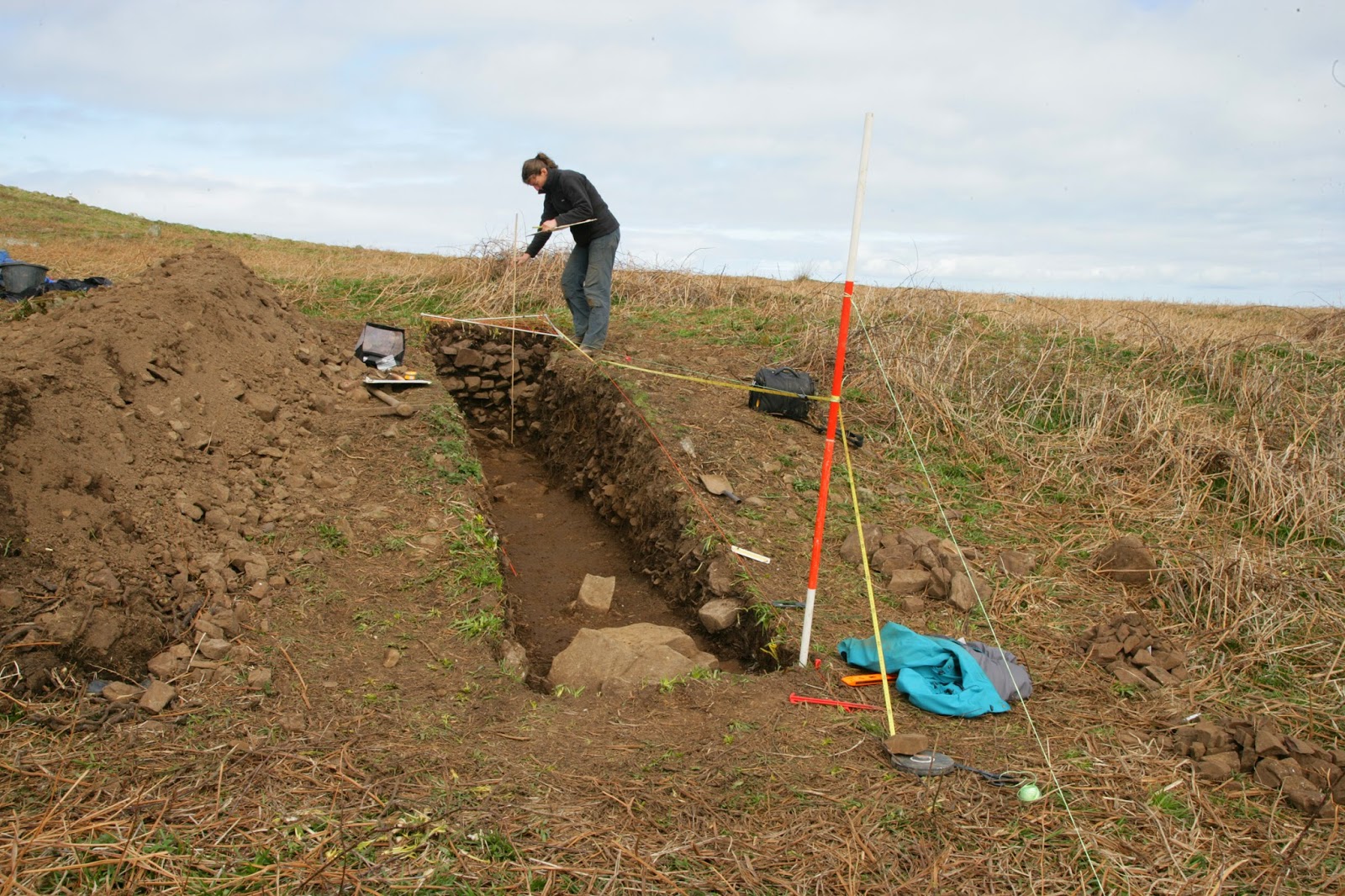
Recording the excavation trench through a cooking mound of burnt stones on Skomer Island. The exposed stone wall of the Iron Age roundhouse can be seen at the end of the trench.
Crown Copyright RCAHMW, DS2014_354_018

The Skomer Island Project team (L-R), Dr Oliver Davis (Cardiff University), Louise Barker (RCAHMW), Dr Bob Johnston (University of Sheffield), Dr Toby Driver (RCAHMW).
Crown Copyright RCAHMW, DS2014_354_006


Skomer Island. A 3D view of the prehistoric field systems (in red) overlying a terrain model generated from airborne laser scanning or LiDAR.
Crown Copyright. Environment Agency. All Rights Reserved. View generated by RCAHMW, Crown Copyright RCAHMW. LD2012_02_01


Tanysgrifiwch i Newyddion Treftadaeth Cymru a chofrestrwch ar gyfer yr RSS porthiant llawn: cliciwch y botwm RSS hwn Subscribe to Heritage of Wales News Blog Posts a thanysgrifiwch!

Rydym hefyd ar gael ar: Facebook Twitter Flickr
Twitter Hashtag: #RCAHMWales

Share this post:

LinkWithin