Swyddi Tanysgrifio i Swyddi Blog Treftadaeth Cymru News      Pob Sylw Tanysgrifio i Heritage of Wales Sylwadau Blog Newyddion     English

Wednesday 30 April 2014

Coffáu Canmlwyddiant y Rhyfel Byd Cyntaf


Cafodd Cofeb RyfelGenedlaethol Cymru ei chodi ym Mharc Cathays ym 1928. Y ddelwedd hon yw un o lawer o ffotograffau o gofebion rhyfel sydd bellach ar gael ar Coflein. .
Rhwng 2014 a 2018 fe fydd y Comisiwn Brenhinol yn cymryd rhan yng nghanmlwyddiant coffáu’r Rhyfel Byd Cyntaf.  Cafodd y rhyfel, a ddechreuodd ym 1914 ac a ddaeth i ben ym 1918, gryn ddylanwad ar lunio’r Gymru rydym ni’n ei hadnabod heddiw. Gan mlynedd wedyn, mae sefydliadau ledled Cymru yn gweithio gyda’i gilydd i wella ein dealltwriaeth o’r rhyfel a’r dinistr enbyd a achosodd, i ymchwilio i’w effeithiau, ac i ddarganfod ei waddol ar gyfer Cymru fodern.

Yn ystod y pedair blynedd nesaf, bydd y Comisiwn yn cyfrannu at goffáu’r Rhyfel Byd Cyntaf yng Nghymru drwy:
  • Arolygu a chofnodi detholiad o safleoedd sy’n gysylltiedig â’r Rhyfel Byd Cyntaf, gan gynnwys gwneud arolygon o’r awyr o safleoedd megis y ffosydd ymarfer ym Mhenally, Sir Benfro, ac ardaloedd hyfforddi eraill.
  • Gwella gwybodaeth yng Nghofnod Henebion Cenedlaethol Cymru sy’n ymwneud â’r Rhyfel Byd Cyntaf.
  • Parhau i gyfoethogi ein gwybodaeth o longddrylliadau a llongau tanfor Almaenig a suddwyd oddi ar arfordir Cymru, a cholledion eraill ar y môr yn ystod yr ymladd.
  • Cynnal arddangosfeydd sy’n tynnu sylw at hanes, effeithiau a gwaddol y Rhyfel Byd Cyntaf yng Nghymru.
  • Cydweithio â Chasgliad y Werin Cymru i wella’r cynnwys sy’n ymwneud â’r Rhyfel Byd Cyntaf.
  • Gweithio mewn partneriaeth â Cadw, English Heritage, Historic Scotland a Chyngor Archaeoleg Prydain ar y prosiect Home Front Legacy 1914-18. Nod y prosiect cymunedol unigryw hwn ar gyfer y DU gyfan yw cofnodi olion safleoedd ac adeiladau sy’n gysylltiedig â’r Rhyfel Byd Cyntaf, a sicrhau bod eu hanes, treftadaeth a storïau’n cael eu cadw i’r cenedlaethau a ddaw (www.homefrontlegacy.org.uk).
  • Manteisio ar gyfleoedd i weithio mewn partneriaeth â chyrff eraill i goffáu digwyddiadau’r Rhyfel Byd Cyntaf, ac i ymchwilio i’w effeithiau a’i waddol ar gyfer pobl Cymru.

Gallwch ddilyn ein gwaith ar y Rhyfel Byd Cyntaf drwy danysgrifio i’n blog, www.newyddiontreftadaethcymru.blogspot.co.uk/, a thrwy ein dilyn ar Twitter yn @RCAHMWales, a #walesremembers.


Tanysgrifiwch i Newyddion Treftadaeth Cymru a chofrestrwch ar gyfer yr RSS porthiant llawn: cliciwch y botwm RSS hwn Subscribe to Heritage of Wales News Blog Posts a thanysgrifiwch!

Rydym hefyd ar gael ar: Facebook Twitter Flickr
Twitter Hashtag: #RCAHMWales

Share this post:

Tuesday 29 April 2014

Archaeoleg yr Uwchdiroedd a Thirweddau Milwrol yng Nghymru


Ysgol undydd a drefnwyd gan y Comisiwn Brenhinol mewn partneriaeth â’r Sefydliad Isadeiledd Amddiffyn ac Ymddiriedolaeth Archaeolegol Clwyd-Powys.
9 Mai 2014. Ardal Hyfforddi Pontsenni,
Aberhonddu, Powys

Fe fydd cyfle, yn ystod cinio, i’r cynadleddwyr weld y lluniau a baentiwyd gan garcharorion rhyfel o’r Eidal a’r Almaen ar wal y Gegin yng Ngwersyll Pontsenni ym 1945-6.  Mae’r olygfa hon yn dangos Castell Heidelberg yn ne’r Almaen (DS2011_331_003).
Bydd Fforwm Archaeoleg yr Uwchdiroedd eleni’n cael ei gynnal ar Ddydd Gwener 9 Mai 2014 yng Nghanolfan y Barcud Coch, Ardal Hyfforddi Pontsenni (SENTA) ym Mhowys. Digwyddiadagored fydd hwn, wedi’i gynnal mewn partneriaeth â’r Sefydliad Isadeiledd Amddiffyn ac Ymddiriedolaeth Archaeolegol Clwyd-Powys. Yn y bore cyflwynir adroddiadau’n deillio o arolygon uwchdirol ar hyd a lled Cymru a neilltuir y prynhawn i bapurau’n ymwneud ag archaeoleg tirweddau milwrol yn uwchdiroedd Cymru. Y tâl cofrestru yw £20, sy’n cynnwys cinio eistedd i lawr, lluniaeth a mynediad.

Bydd hwn yn gyfle prin i fynychu digwyddiad yn yr ardal hyfforddi a chlywed mwy am archaeoleg Mynydd Epynt a thirweddau archaeolegol eraill yng Nghymru, ac i ymweld â safleoedd ar y maes yng nghwmni archaeolegwyr a phersonél milwrol. Fe fydd nifer cyfyngedig o leoedd, felly bwciwch yn gynnar.

Rhoddir manylion pellach am y digwyddiad a’r trefniadau bwcio ar wefan y Comisiwn Brenhinol. I gael rhagor o wybodaeth, cysylltwch â David Leighton yn david.leighton@cbhc.gov.uk neu drwy ffonio 01970 621204


Tanysgrifiwch i Newyddion Treftadaeth Cymru a chofrestrwch ar gyfer yr RSS porthiant llawn: cliciwch y botwm RSS hwn Subscribe to Heritage of Wales News Blog Posts a thanysgrifiwch!

Rydym hefyd ar gael ar: Facebook Twitter Flickr
Twitter Hashtag: #RCAHMWales

Share this post:

Thursday 24 April 2014

Cwt Nissen: “un o glasuron dylunio mwyaf yr ugeinfed ganrif”


Ffotograff: Dau Gwt Nissen yn Nepo Arfau’r Llynges Frenhinol (RNAD), Trecŵn, Sir Benfro, NPRN 96059

Un o adeiladweithiau milwrol mwyaf adnabyddus y byd yw’r Cwt Nissen. Cafodd y dyluniad syml ar siâp hanner silindr ei ddatblygu gan ŵr o dras Ganadaidd-Americanaidd, y Capten Peter Norman Nissen, o 29ain Cwmni y Peirianwyr Brenhinol, ym 1916.

Cafodd y cytiau eu defnyddio gyntaf yn nes ymlaen yn y flwyddyn honno yn Hesdin, Ffrainc. Byddai’r cytiau ysgafn, rhad a symudol yn cael eu cynhyrchu mewn tri lled – 16, 24 a 30 troedfedd – a châi’r adrannau mewnol eu gosod ar 6 throedfedd fel bod modd creu cwt o unrhyw hyd yn ôl y gofyn. Gallai un lori fyddin 3 tunnell gludo’r uned safonol gyfan. Roedd y llwyth yn cynnwys haen allanol o haearn rhychiog, leinin mewnol o bren, fframiau metel ar ffurf hanner cylch, drws pren, a ffenestri oelcloth. Gallai tîm arbenigol o chwe dyn godi cwt ar sylfaen goncrit barod mewn pedair awr. Yr amser byrraf ar gyfer codi cwt oedd 1 awr 27 munud. Amcangyfrifir i 100,000 o unedau gael eu cynhyrchu yn ystod y rhyfel.

Roedd y Cytiau Nissen yn cwrdd â’r galw am adeiladau dros dro i gartrefu’r miloedd ar filoedd o filwyr a oedd newydd ymuno â’r fyddin. Roedd y dyluniad hyblyg yn golygu y gallai’r cytiau gael eu defnyddio hefyd fel ceginau, ystafelloedd bwyta, storfeydd, gorsafoedd trin clwyfau, eglwysi ac ati.
Lluniad: O Gasgliad Medwyn Parry.

Roedd Nissen wedi codi patent am ei ddyluniad yn y DU, Awstralia, De Affrica, Canada a’r Unol Daleithiau. Ond gwrthododd unrhyw freindaliadau yn ystod y Rhyfel Byd Cyntaf, a gwnaeth y cwmni gweithgynhyrchu yr un peth eto yn ystod yr Ail Ryfel Byd.

Nid Capten Nissen oedd yr unig un a fu’n datblygu cytiau dros dro yn ystod y Rhyfel Byd Cyntaf. Enghreifftiau eraill oedd Cytiau Armstrong, Cytiau Aylwin, Cytiau Forest, Cytiau Cludadwy Tarrant, a Chytiau Weblee, yr oedd pob un ohonynt wedi’u henwi ar ôl swyddogion gyda’r Peirianwyr Brenhinol. Cafodd dyluniadau tebyg eu datblygu yn ystod yr Ail Ryfel Byd hefyd, er enghraifft, Cytiau Abbey, Cytiau Iris, Cytiau Romney, a Chytiau Tufton. Ond nid oedd yr un o’r rhain mor hollbresennol ag un o glasuron dylunio mwyaf yr ugeinfed ganrif, y Cwt Nissen eponymaidd. Mae’r cysyniad syml wedi parhau i gael ei ddefnyddio am ganrif bron, heb unrhyw newid i’w siâp sylfaenol.
Gan Medwyn Parry.


Tanysgrifiwch i Newyddion Treftadaeth Cymru a chofrestrwch ar gyfer yr RSS porthiant llawn: cliciwch y botwm RSS hwn Subscribe to Heritage of Wales News Blog Posts a thanysgrifiwch!

Rydym hefyd ar gael ar: Facebook Twitter Flickr
Twitter Hashtag: #RCAHMWales

Share this post:

Wednesday 23 April 2014

The Atlanterra Project II: Slate Studies


The Atlanterra project has also led to cultural tourism and heritage maps and guides of a number of mining fields including the Mapa de Patrimonia Minero de Galicia, (IGME, Madrid, 2013) and the Slate quarrying & mining sites of the French/Breton border in ‘Sur le Chemin des Ardoisières’ (Marie de Noyant-la-Gravoyère, 2013). Mapping and publication of mining on the iron pyrites belt of Portugal is also being published as part of the project. Mapping of the Swansea Valley coalmining field and its eighteenth and early nineteenth-century railways in south Wales has also led to a re-analysis of the origins of the public railway published in S. R. Hughes, 2010, ‘The Emergence of the public railway in Wales’, in G. Boyes (Ed.), Early Railways 4: Papers from the Fourth International Early Railways Conference (Six Martlets, Sudbury, 2010), 107-124. The international diffusion of narrow-gauge railway practice from Wales to Sardinia is discussed in Hughes, Stephen, 2011. ‘Piercy, Benjamin (1827-88), railway builder. Oxford Dictionary of National Biography, Oxford, Oxford University Press [http://www.oxforddnb.com].

The geological analysis of building-stones in the area studied as part of the Atlanterra project has included an analysis of part of the World Heritage Pilgrimage route to Santiago Compostella in a volume by Martinez, R.J. & Diaz Martinez, E. on Las piedras del Camino de Santiago en Galicia, (Instituto Geolόgico y Minero de España, Madrid, 2013); available at http://igmepublicaciones.blogspot.com.es/p/coleccion-guias-geologicas.html#!/p/coleccion-guias-geologicas.html.

A major aim of the Atlanterra project has been the heritage contribution to the valorisation and regeneration of old mining fields. Part of the explanation of this process has been published as Stephen Hughes, 2011 ‘The Comparative Regeneration of the Blaenavon and Pontcysyllte World Heritage Areas’, in Industrie Archäologie 10 (2011) (Industrial Heritage –Ecology & Economy: XIV. International TICCIH Congress 2009 in Freiberg, Germany – Selected Papers), 55-9.

The Atlanterra Project has also contributed to the process whereby TICCIH has agreed with ICOMOS to restart the series of World Heritage Studies. The background to this has already been explained in Stephen Hughes 2012, ‘Thematic World Heritage Studies’ in James Douet (Ed.), Industrial Heritage Re-tooled: The TICCIH guide to Industrial Heritage Conservation (TICCIH, Michigan, USA & Carnegie, Lancaster), 2012, 174-181.

The Atlanterra Project has provided the funding for the process of the compilation of initial studies of the slate and building-stone industries to be started. An initial summary of some of this comparative work has been published by Dr. David Gwyn in Anjou and Gwynedd: Slate Landscapes (Snowdonia National Park, Plas Tan y Bwlch, 2013). Much more and analytical detail of the north Wales Slate Industry will shortly be published in Gwyn, D., Welsh Slate: Archaeology & History of an Industry (RCAHMW, Aberystwyth, 2014).

The Atlanterra partnership has included representatives of areas that had some of the biggest international slate-producing industries. The largest industry developed in the Loire Valley in France in the medieval and post-medieval period and then was overtaken in scale by the nineteenth-century Welsh industry. In the twentieth-century the Spanish slate industry has become the largest in Europe.  Discussion and field visits have allowed draft documents to be produced as a foundation for future World Heritage Studies of slate and building-stone to be produced in consultation with a wider range of TICCIH members.

The methodology of producing animations for industrial archaeological interpretation continues and the annual Digital Past Conferences are one vehicle for carrying this discussion forward (check www.rcahmw.gov.uk for future conferences). Some further work has been carried-out as part of the Metal Links Irish-Welsh partnership led by the Royal Commission in Wales and this will be reported on in a future Bulletin.

Stephen Hughes.
Projects Director, Royal Commission on the Ancient and Historical Monuments of Wales & TICCIH Secretary

Further Reading:


Tanysgrifiwch i Newyddion Treftadaeth Cymru a chofrestrwch ar gyfer yr RSS porthiant llawn: cliciwch y botwm RSS hwn Subscribe to Heritage of Wales News Blog Posts a thanysgrifiwch!

Rydym hefyd ar gael ar: Facebook Twitter Flickr
Twitter Hashtag: #RCAHMWales

Share this post:

Tuesday 22 April 2014

The Atlanterra Project I: the Development of Interpretative Animation & International Slate Studies


The development and international diffusion of innovatory survey and presentation techniques was one of the objectives of the four year Atlanterra: Green Mines Project which was brought to a conclusion in the early months of 2014.  The Project Partners also laid the foundations for international studies of the building-stone and slate industries.

The first four months of 2014 saw the culmination of a four year project that examined the valorisation of the mining heritage and laid the foundations for World Heritage Studies of the Building-stone and slate industries. It examined the mining heritage from both a geological and archaeological/historical viewpoint and explored how to showcase this heritage using the application of new digital technologies. As a result The Royal Commission recently won the first Peter Neaverson Award for Digital Innovation given by the British Association for Industrial Archaeology for its animation of world’s largest early/mid 19th century copper works - Hafod Copperworks in Swansea, south Wales, U.K. which can be viewed online at  http://www.youtube.com/watch?v=1Y8DAXaMihc. Other industrial archaeological interpretative animation films can be viewed at http://www.youtube.com/user/RCAHMWales .

The two surviving engine sheds and rolling machinery at the Hafod Copper Works site. Crown Copyright: RCAHMW


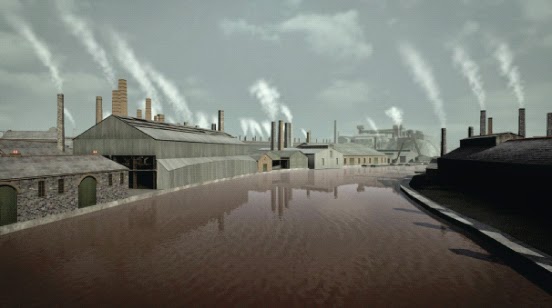
Utilising a wealth of survey carried out by the RCAHMW and their in-house expertise in industrial archaeology, combined with historic images from the West Glamorgan Record Office and Swansea Museum, the animation recreates the detail of buildings, machinery and processes on the site as well as a sense of the highly industrial nature of the Lower Swansea Valley in the late nineteenth and early twentieth century. The establishment of authenticity by analytical survey must underpin both the conservation and presentation of internationally important industrial archaeology sites as discussed in Stephen Hughes, 2011 ‘Authenticity and Conservation in World Heritage’ in ICOMOS  China, Wuxi Forum on the Conservation of China’s Cultural Heritage, Conservation of Heritage Canals: Material for Academic Exchanges (ICOMOS China, Wuxi, 2011), 9-13.
Stills from the animation. Crown Copyright: RCAHMW

The Atlanterra: Green Mines II European Inter-regional Project was formed in February 2010 by a group of geological, archaeological, tourism and regeneration organisations from France, Spain, Portugal, Ireland and Wales led by the municipality of Noyant-la-Gravoyère. An understanding of historic mining fields can only be achieved by a determination of their geological structure considered together with their archaeological remains. Cosequently the project partners have included the Instituto Geologico y Minero de España (IGME), the Laboratorio Nacional de Energia e Geologia of Portugal (LNEG) and the Geological Survey of Ireland (GSI). The Royal Commission on the Ancient and Historical Monuments of Wales (RCAHMW) has led on the archaeological objectives that included the demonstration and diffusion of digital and laser-scanning techniques.

Some 19 project blogs, describing the survey work undertaken, some based on the former centre of the world slate industry in the mountains of north Wales were posted here at http://heritageofwalesnews.blogspot.com/  including  ‘2011/10/atlanterra-project-business-meeting.html’ , ‘2010/10/survey-at-maenofferen-slate-quarry.html’ and ‘2010/8/periant-arbrofol-codi-cwch-camlas.html’ [i.e. looking for an 18th century canal boat lift]. The slate industry was identified as being of international importance in S. R. Hughes, D. Gwyn & J. Alfrey,  2010, ‘Wales in the Industrial and Modern Period (Post 1750), Review of the Research Framework for the Archaeology of Wales, 7pp.’ at http://www.archaeoleg.org.uk/pdf/reviewdocs/industrialreview.pdf.

Laser-scanning of a significant site such as that carried-out in the Vivian Slate Quarry, part of one of the world’s biggest nineteenth-century mountain terraced slate quarries of Dinorwig, Llanberis, north Wales can be viewed at http://www.youtube.com/watch?v=PH1Gf1LY2Ms. These laser-scans of large industrial landscapes can simply be used to produce on-line ‘fly-throughs’ and seem to have an almost magical other-worldly feel that draws new audiences to go and explore these sites for themselves. The Royal Commission also commissioned an equally attractive scan of an underground mine-pumping waterwheel in a lead mine in mid Wales which can be viewed online at http://welshminestrust.org/ystrad-einion.

This work helped inspire our Atlanterra project partners to produce their own ‘fly-through’ films.  One has just been produced by the Copper Coast Geopark in County Waterford in Ireland of the conserved copper mine engine-houses on the cliff at Tankardstown and can be viewed at http://www.youtube.com/watch?v=rcqZfnXcJjk. Another has a fly-through of the remaining dry underground tunnels and mineral formations in the mine. This includes a 3D digital representation of all the levels, shafts and tunnels ever worked in the mine constructed from the historical mine plans archive held by the Geological Survey of Ireland. This can be viewed at http://www.youtube.com/watch?v=f1w1sBfbN1s. The tours also encourage cultural tourism from the Copper Coast Geopark Centre (http://www.coppercoastgeopark.com) where they can be viewed on-site.

The digital and laser surveys have helped produce high quality results upon which animators can build 3D models conveying reliable information to cultural tourists. The Royal Commission’s initial animation of the building of the World Heritage Pontcysyllte Aqueduct in north Wales available at http://www.youtube.com/watch?v=nqeCu6jd9W0, produced in 2009, lacked a sound track. The Hafod Copper Works animation has soundtracks in the English and Welsh languages http://www.youtube.com/watch?v=V2jH8D_0iV0 and as well as being available on youtube these animations are shown at the Pontcysyllte World Heritage Visitor Centre, the National Waterfront Museum in Swansea and by the Swansea Riverboat Trust. The Hafod Animation also has character animations of copper-workers.

The Geological Survey of Ireland subsequently produced a visualisation of the copper-ore dressing-floors at Knockmahon and the Laboratorio Nacional de Energia e Geologia of Portugal has produced an animation of historical conical-shaped copper-roasting structures in use as part of the Teleiras mining process at Aljustrel.

The design and distribution of workers’ housing and settlements were also compared as part of the Atlanterra Project (online database of workers housing in Wales is available as part of ‘Coflein’ at www.coflein.gov.uk). In Wales animations of the key 1790s ironworkers ‘Bunkers Row’ Houses & institutional buildings at Blaenavon World Heritage Site (south Wales) was produced and can be viewed online in English at  http://www.youtube.com/watch?v=3ZUg94GMp3s and in the Welsh-language at http://www.youtube.com/watch?v=KIV21l-Mw1Q. Both films are now shown on-site at the World Heritage Centre in Blaenavon. The animations show clearly how urban ideas of designing ‘back-to-back’ houses from the English west Midlands were imported to rural south Wales with the influx of both capital and key workers to the region. They also show how the iron workers built their own protestant Welsh-language chapels in the Italianate style to distinguish them from the gothic English-language Anglican churches provided by the ironmasters. The international background to this has been discussed in S. R. Hughes, 2010, ‘Attitudes to Religion, Education, and Status in Worker Settlements: The Architectural and Archaeological Evidence from Wales’, in M. C. Beaudry & J. Symonds (Ed.), Interpreting the Early Modern World: Transatlantic Perspectives (Springer, New York, in series C.E. Orser (Ed.) Contributions to Global Historical Archaeology, 2010), 197-225.  The international context has been expanded upon in Stephen Hughes, 2011 ‘The Architecture of Nonconformist Christian Religion and National Identity’ in P. Bellamy & Guarin Montpetit (Ed.), Religion: Beliefs, Theories and Societal Effects, (Nova Science Publishers, New York, 2011), 1-33 (2011).

International exchanges and visits to key slate-quarrying and mining sites were held during two international conferences held as part of the Atlanterra Project in 2012: at Plas Tan-y-Bwlch in north Wales (in conjunction with ICOMOS-UK) and at Nantes in France. Papers from the latter conference are available in Atlanterra, ‘Valorisation du Patrimoine Minier’ Actes du Colloque18 et 19 Septembre 2012, Nantes (Noyant-la-Gravoyère, 2013).

Animations of two of the major slate-quarrying and mining sites at Maenofferen Blaenau Ffestiniog and Vivian’s Quarry at the Dinorwig slate-quarrying complex have been produced as part of the Atlanterra Project and will be available at http://www.youtube.com/user/RCAHMWales. An animation of the railway inclined-planes at the Vivian’s Slate Quarry is already available at http://www.youtube.com/watch?v=UUUAfQOnDnk.

During discussions with partner organisations it was decided that previous animations of sites such as the Hafod Copper Works lacked photographs showing the present state of the works. The latest slate animations address this deficiency by including both terrestrial and aerial photographs of the sites and landscapes. They also use an alternative narrative methodology by using sub-titles rather than spoken narratives.

In 2012 the Atlanterra project also sponsored the Royal Commission’s annual international conference on digital innovation Digital Past (details at www.rcahmw.gov.uk). Part of the output of that conference was the Atlanterra sponsored booklet Rhannu Ein Gorffennol Digidol: Sharing Our Digital Past (RCAHMW, Aberystwyth, 2012) to give guidance on current digital innovations and their use. Much of this is available online at: http://www.slideshare.net/trompet/sharing-our-digital-past-digital-innovation-at-the-royal-commission-1-of-2. One very useful survey tool is aerial laser-scanning (also used by GSI in a Maritime context to detect wrecks as well as undersea deposits) which is explained at: http://www.rcahmw.gov.uk/HI/ENG/Publications/Digital+Reports/Processing+and+Working+with+LiDAR+Data+in+ArcGIS%3A+A+Practical+Guide+for+Archaeologists.

By Stephen Hughes.
Projects Director, Royal Commission on the Ancient and Historical Monuments of Wales & TICCIH Secretary

Further Reading:
  • The Atlanterra Project II: Slate Studies
    23 Apr 2014
    The Atlanterra project has also led to cultural tourism and heritage maps and guides of a number of mining fields including the Mapa de Patrimonia Minero de Galicia, (IGME, Madrid, 2013) and the Slate quarrying & mining sites ...


Tanysgrifiwch i Newyddion Treftadaeth Cymru a chofrestrwch ar gyfer yr RSS porthiant llawn: cliciwch y botwm RSS hwn Subscribe to Heritage of Wales News Blog Posts a thanysgrifiwch!

Rydym hefyd ar gael ar: Facebook Twitter Flickr
Twitter Hashtag: #RCAHMWales

Share this post:

Monday 14 April 2014

Britain From Above at Cardigan Library


On Monday 31 March, Britain From Above’s Activity Officer and Community Archaeologists from the Royal Commission on Ancient and Historical Monuments Wales were in Cardigan Library as part of the nationwide Spring Online campaign, helping senior members of the community explore and use the internet. Over thirty people including residents from the local community and further afield came along to hear about the Britain from Above project for the first time. They were astonished by the range of the collection and the quality of the images.

The website is a fantastic online resource showcasing a previously unseen collection of aerial photographs of Wales, Scotland and England from the pioneering age of aviation. The collection covers the years 1919-1953, a period when the landscape of Britain was undergoing drastic change.

After hearing about the project and seeing the remarkable collection, they were all keen to log in and get started! Once registered, people were eager to start looking for places they knew well. There was an engaging mix of interests drawing people to the event, some came along who had a strong fascination with local history and were enthusiastic to find out how to use the site for their own research whilst other people enjoyed looking for places they knew when they were growing up.


It was a successful day with attendees happily sharing their stories of Cardigan from both their research and personal memories. Everyone who joined us left knowing more about the Britain from Above project and the ways it could be explored and used as a free research resource.

Tanysgrifiwch i Newyddion Treftadaeth Cymru a chofrestrwch ar gyfer yr RSS porthiant llawn: cliciwch y botwm RSS hwn Subscribe to Heritage of Wales News Blog Posts a thanysgrifiwch!

Rydym hefyd ar gael ar: Facebook Twitter Flickr
Twitter Hashtag: #RCAHMWales

Share this post:

Wednesday 9 April 2014

First Modern Excavation on Skomer Seeks to Explore and Date Island’s Prehistoric Settlements


The Skomer Island Project team (L-R), Dr Oliver Davis (Cardiff University), Louise Barker (RCAHMW), Dr Bob Johnston (University of Sheffield), Dr Toby Driver (RCAHMW)
 
A collaborative research project between staff of the Royal Commission, The University of Sheffield and Cardiff University has just completed a third season of fieldwork and research on the renowned prehistoric landscape and national nature reserve of Skomer Island in Pembrokeshire, west Wales. This included the historic, first modern excavation in the island’s history, exploring a mound of burnt stone alongside a prehistoric settlement, which produced flintwork, datable charcoal and the first fragments of prehistoric pottery from the island.

Skomer is a heavily protected landscape famous for its puffins and other breeding seabirds, but it is also home to some of the best preserved prehistoric field systems and hut settlements anywhere in Britain. In 2011 the Royal Commission used airborne laser scanning (LiDAR) to map comprehensively the island’s field systems. This work discovered evidence for a longer chronology to the fields than had previously been thought. The Skomer Island Project built on this work in 2012 with the first use of geophysics on the island, which showed that unrecorded prehistoric fields and settlements survive beneath the modern fields in the centre of the island.

Despite two major studies of the island’s archaeology in the twentieth century, no modern excavation had been attempted. In order to refine a chronology, the team set out in 2014 to undertake the first modern excavation to locate buried charcoal and other evidence suitable for radiocarbon dating and scientific analysis. It was decided to target one of the many substantial mounds of burnt stone in the north of the island, which are found alongside the prehistoric hut groups, thought to have built up from cooking activities. Although few finds were encountered in the mound itself, a sealed soil layer was uncovered a metre down, which yielded charcoal, flint tools and fragments of prehistoric pottery. Excavations were recorded using Structure from Motion, a technique which builds individual photographs into a 3D digital model of the land surface. The hard work of post-excavation now begins to analyse the discoveries and learn more about prehistoric life on Skomer.


Accurately recording prehistoric finds and charcoal samples in three dimensions using GPS.

The Skomer Island Project team would like to thank the Skomer Island Wardens, the Wildlife Trust of South and West Wales and Natural Resources Wales for accommodating the archaeological work and granting permission to work in a Site of Special Scientific Interest. They are also grateful to Cadw for Scheduled Monument Consent, which allowed the work to proceed. The Royal Commission’s online records for the work can be found here.

By Toby Driver

 Further Reading:


Tanysgrifiwch i Newyddion Treftadaeth Cymru a chofrestrwch ar gyfer yr RSS porthiant llawn: cliciwch y botwm RSS hwn Subscribe to Heritage of Wales News Blog Posts a thanysgrifiwch!

Rydym hefyd ar gael ar: Facebook Twitter Flickr
Twitter Hashtag: #RCAHMWales

Share this post:

Tuesday 8 April 2014

Archaeology and the Sea: Aberystwyth hosts CBA Wales Spring Meeting


On Saturday 5th April CBA (Council for British Archaeology): Wales held its Spring Meeting at Y Morlan Centre, Aberystwyth. The theme was Archaeology and the Sea: Coastal Archaeology in Wales. The Royal Commission provided exhibition material, including a display on Aberystwyth’s storm-damaged Bathrock Shelter and aerial photographs of the coastal davastation caused by the recent storms of 2014.

CBA-sponsered Community Archaeologists, Kimberly Briscoe and Sarahjayne Clements, were on hand to discuss their current community project, The Coastal Heritage of Borth and Ynyslas. Both are completing CBA-sponsered work placements with the Royal Commission. The project has proved hugely popular, with an ever-increasing number of Borth and Ynyslas residents (past and present) eager to participate and to contribute memories, photographs and documents. Material generated will be added to the National Monuments Record (NMR) and uploaded to People’s Collection Wales, creating a permanent digital record. The project’s facebook page can be found at https://www.facebook.com/pages/The-Coastal-Heritage-of-Borth-and-Ynyslas/277783665703802


The Royal Commission’s CBA work placements, Kimberley and Sarahjayne, discuss the coastal heritage of Borth and Ynyslas

During the afternoon’s symposium, Mike Roberts (Bangor University) detailed current research on the history of north Wales’ sea level change, including the fascinating results of a multibeam sonar survey of the entire Anglesey coast. A causeway linking Anglesey to the mainland is now thought to have been submerged for the first time at around  8,400BP. Stephen Briggs (independent researcher) then gave an informative talk about the remains of ancient landscapes beneath the beach at Llanrhystud. Various recently exposed features include post-glacial peat deposits and parts of a cobbled track thought to be associated with nearby post-medieval limekilns. Paul Huckfield (Gwent-Glamorgan Archaeological Trust) reviewed recent discoveries on the south Wales coast revealed by the 2014 storms. They  include a cemetery at Monknash, two canon at Porthcawl and a number of ship wrecks, discovered as a result of the Welsh Archaeological Trusts’ Arfordir scheme. The pan-Wales scheme brings together local volunteers to record and moniter their coastal heritage and incorporate the results into the regional Historic Environment Records. One of the shipwrecks, identified through the Royal Commission’s Maritme Database, is thought to be that of the iron-hulled Ben-y-Gloe, wrecked on its maiden voyage from Penarth in 1886.

The Royal Commission’s Maritime Officer, Deanna Groom, then explained the Commission’s leading role in the recording, curating and supplying of information regarding Wales’ maritime heritage. The Commission’s 9498 Maritime records comprise around 9% of the entire National Monuments Record. They include coastal and intertidal features, submerged landscape features, historic seascape features, 6000+ shipwrecks and 349 downed aircraft.


Royal Commission Maritime Officer, Deanna Groom, talks about Wales’ rich maritime archaeology

Deanna also outlined recent work with Kimberley and Sarahjayne on the Royal Commission and Cadw’s Shipwrecks Project, designed to investigate the wider impact of the Royal Charter Gale of 1859. The Royal Charter was one of 50+ vessels driven onto the Welsh coast by the gale. The project involved working with Welsh Baccalaureate students from Pembrokeshire College, engaging them with the story of the storm and their local maritime heritage. The project also demonstrated how local resources can be used for research, with Pembrokeshire Archives facilitating a ‘treasure hunt’ across shipping registers, burial records and census returns. Material generated by the project can be viewed by visiting ‘The Great Storm of 1859’ http://www.peoplescollectionwales.co.uk/collections/377940 and ‘Pembrokeshire Shipwrecks Project’ http://www.peoplescollectionwales.co.uk/node/380977 on the freshly relaunched People’s Collection Wales website.


Some of the items uploaded by the Royal Commission to People’s Collection Wales as part of ‘The Great Storm of 1859’ collection

The afternoon’s final speaker was Martin Bates (University of Wales Trinity St David, Lampeter), who discussed the results of recent archaeological investigation at Borth and Clarach. Recent coastal change, coupled with this year’s storms, has revealed extensive prehistoric peat exposures, within which are contemporary organic remains and animal and human (including a child’s) footprints. At Borth, a combination of survey, sampling and archaeological excavation has facilitated far greater understanding of the foreshore’s underlying geology and the reconstruction of its post-glacial landscape.

The event proved a great success, providing an informative insight into the wealth of archaeology located around Wales’ coastline, as well as highlighting its fragile and precarious nature.

By Nikki Vousden


Tanysgrifiwch i Newyddion Treftadaeth Cymru a chofrestrwch ar gyfer yr RSS porthiant llawn: cliciwch y botwm RSS hwn Subscribe to Heritage of Wales News Blog Posts a thanysgrifiwch!

Rydym hefyd ar gael ar: Facebook Twitter Flickr
Twitter Hashtag: #RCAHMWales

Share this post:

Wednesday 2 April 2014

Y Daith Gerdded Fawr: Taith Dywys Fan Llia a Fan Dringarth, 3 Mai


Y dirwedd weundirol donnog, yn edrych ar draws dyffryn Llia uchaf i'r de-ddwyrain

Ar Ddydd Sadwrn, 3 Mai, bydd David Leighton, arbenigwr y Comisiwn Brenhinol ar archaeoleg yr uwchdiroedd, yn arwain taith dywys i Fan Llia a Fan Dringarth yn harddwch Bannau Brycheiniog. Ardal ddistaw ar gyfer cerdded yw hon, i ffwrdd o’r llwybrau poblogaidd, ac mae’r daith ar hyd gweundiroedd agored yn nodedig am yr henebion cynhanesyddol, canoloesol ac ôl-ganoloesol y gellir eu gweld ar hyd y llwybr. Rhai o uchafbwyntiau’r daith fydd Maen Llia, carreg enfawr o dywodfaen sy’n un o’r meini hirion cynhanesyddol mwyaf yn Ne Cymru (NPRN: 84541), yr hen dollffordd a oedd, o bosibl, yn dilyn llwybr Sarn Helen (NPRN:407122), ac olion helaeth aneddiadau hanesyddol niferus yng Nghwm Nant y Gaseg.
Bydd y daith hon yn dilyn llwybr ar hyd llethrau gorllewinol Fan Llia i ben dyffryn Llia, ar draws Bryn Melyn a Chefn Perfedd i mewn i Gwm Dringarth a dyffrynnoedd llednant islaw Fan Dringarth, ac i lawr Cwm Dringarth uwchlaw Cronfa Ddŵr Ystradfellte, gan ddychwelyd i’r maes parcio ar draws rhan ddeheuol Cefn Perfedd, cyfanswm pellter o ryw 13.5 km (8.5 milltir).
Maen Llia o'r gogledd-orllewin


Bydd y cerddwyr yn cyfarfod am 10.30am yn yr ardal parcio a phicnic (SN92721646) ar y ffordd annosbarthedig rhwng Ystradfellte a Heolsenni. Gellir cyrchu’r ffordd hon o’r A4215 rhwng Pontsenni a Libanus.

I gael rhagor o wybodaeth, e-bostiwch Nicola Roberts, nicola.roberts@rcahmw.gov.uk neu ffoniwch 01970 621200. Bydd lleoedd i 30 o gerddwyr ar y mwyaf ar y daith gerdded hon.

Ceir disgrifiad llawnach o’r daith, ynghyd â gwybodaeth am deithiau a safleoedd eraill ar hyd y llwybr, yn TheWestern Brecon Beacons: The Archaeology of Mynydd Du and Fforest Fawr gan David Leighton, y gellir ei brynu gan y Comisiwn Brenhinol.

Trefnwyd y daith hon fel rhan o raglen Taith Gerdded Fawr Ramblers Cymru a Cadw. I gael manylion teithiau eraill drwy ardaloedd hanesyddol yn ystod y gwanwyn, defnyddiwch Leolwr Digwyddiadau Cadw yn: http://cadw.wales.gov.uk/events/ 


Tanysgrifiwch i Newyddion Treftadaeth Cymru a chofrestrwch ar gyfer yr RSS porthiant llawn: cliciwch y botwm RSS hwn Subscribe to Heritage of Wales News Blog Posts a thanysgrifiwch!

Rydym hefyd ar gael ar: Facebook Twitter Flickr
Twitter Hashtag: #RCAHMWales


Share this post:

LinkWithin